MANILA, Dec. 6 — Typhoon Ruby makes landfall over Samar, heads for Masbate. After Typhoon “Ruby” made landfall over Eastern Samar on Saturday evening, the state weather agency Philippine Atmospheric Geophysical and Astronomical Services Administration (PAGASA) placed 49 areas in the country including Metro Manila under public storm warning signals.

PAGASA weather forecaster Fernando Cada said that typhoon “Ruby” is now heading towards Masbate.
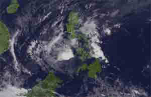
Cada said that as of 10 p.m., the eye of the typhoon was located in the vicinity of Dolores, Eastern Samar or at 140 km East Southeast of Catarman, Northern Samar (11.9°N, 125.8°E), still packed with maximum sustained winds of 175 kph near the center and gustiness of up to 210 kph.
Cada said that typhoon “Ruby” movement is West Northwest at 15 kph maintaining its speed.
It was forecast to make a second landfall on Sunday afternoon in the vicinity of Masbate associated with strong winds, storm surge (up to 4.5 meters) and heavy to torrential rainfall.
The estimated rainfall amount is from 10-30 mm per hour (heavy – torrential rains) within the 600 km diameter of the typhoon.
The areas under Signal No. 3 (winds of 101-185 kilometers per hour expected in at least 18 hours) are: the provinces of Romblon, Catanduanes, Camarines Sur, Albay, Sorsogon,and Masbate, including Burias and Ticao Island in Luzon; Northern Samar, Eastern Samar, Samar, Leyte and Biliran in Visayas.
”Residents in low lying and mountainous areas are alerted against flashfloods and landslides. Likewise, those living along the coast are warned on the occurrence of big waves associated with storm surge which may reach up to 4.5 meters,” it warned.
Areas under Storm Signal No. 2 (Winds of 61-100 kilometers per hour expected in at least 24 hours) are: Camarines Norte, Southern Quezon, Marinduque, Oriental Mindoro and Occidental Mindoro in Luzon; Northern Antique, Aklan, Semirara Group of Islands, Capiz, Northern Iloilo, Northern Cebu including Cebu City, Bantayan and Camotes Island, and Southern Leyte.
”Residents in low lying and mountainous areas are alerted against possible flashfloods and landslides,” it warned.
Public storm warning Signal No. 1 (Winds of 30-60 kph is expected in at least 36 hours) is hoisted over Pampanga, Bulacan, Rest of Quezon, Rizal, Cavite, Laguna, Batangas, Lubang Island, Calamian Group of Islands, Cuyo and Metro Manila in Luzon; rest of Antique, Iloilo, Guimaras, Negros Occidental, Negros Oriental, Rest of Cebu and Bohol in the Visayas; and Surigao del Norte including Siargao Island and Dinagat Province in Mindanao.
”These areas will have occasional rains with occasional gusty winds,” it warned.
Due to the effects of typhoon “Ruby” and the Northeast Monsoon, sea condition will be rough to very rough over the seaboards of Northern Luzon, eastern seaboard of Central and Southern Luzon, seaboards of Visayas and over northern and eastern seaboards of Mindanao.
Fisherfolks and those using small seacraft are advised not to venture out over the said seaboards.
Typhoon “Ruby” is forecast to be at 35 km Northeast of Romblon, Romblon by Sunday evening.
By Monday evening, it is expected to be at 235 km West Northwest of Calapan City, Oriental Mindoro.
By Tuesday evening, “Ruby” is expected to exit Philippine Area of Responsiblity (PAR) or at 595 km West of Calapan City, Oriental Mindoro.(PNA)

- Ang mga Masisipag na Magbabade - June 30, 2026
- Ang Mga Magbabade ng Isda, Part 2 - June 29, 2026
- Ang Mga Magbabade Sa Pagawaan Ng Tuyong Isda, P1 - June 28, 2026